


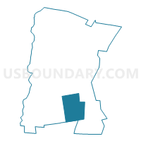
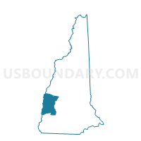
TOWN OF LEMPSTER Voting District, Sullivan County, New Hampshire
About
Outline

Summary
| Unique Area Identifier | 616495 |
| Name | TOWN OF LEMPSTER Voting District |
| County | Sullivan County |
| State | New Hampshire |
| Area (square miles) | 32.77 |
| Land Area (square miles) | 32.35 |
| Water Area (square miles) | 0.43 |
| % of Land Area | 98.70 |
| % of Water Area | 1.30 |
| Latitude of the Internal Point | 43.23656420 |
| Longtitude of the Internal Point | -72.18486910 |
Maps
Graphs
Select a template below for downloading or customizing gragh for TOWN OF LEMPSTER Voting District, Sullivan County, New Hampshire


Neighbors
Neighoring Voting District (by Name) Neighboring Voting District on the Map
- TOWN OF ACWORTH Voting District, Sullivan County, NH
- TOWN OF GOSHEN Voting District, Sullivan County, NH
- TOWN OF MARLOW Voting District, Cheshire County, NH
- TOWN OF UNITY Voting District, Sullivan County, NH
- TOWN OF WASHINGTON Voting District, Sullivan County, NH
Top 10 Neighboring County Subdivision (by Population) Neighboring County Subdivision on the Map
- Unity town, Sullivan County, NH (1,671)
- Lempster town, Sullivan County, NH (1,154)
- Washington town, Sullivan County, NH (1,123)
- Acworth town, Sullivan County, NH (891)
- Goshen town, Sullivan County, NH (810)
- Marlow town, Cheshire County, NH (742)
Top 10 Neighboring Elementary School District (by Population) Neighboring Elementary School District on the Map
- Goshen-Lempster Cooperative School District, NH (1,964)
- Unity School District, NH (1,671)
- Washington School District, NH (1,123)
- Marlow School District, NH (742)
Top 10 Neighboring Unified School District (by Population) Neighboring Unified School District on the Map
Top 10 Neighboring State Legislative District Lower Chamber (by Population) Neighboring State Legislative District Lower Chamber on the Map
- State House District 4, Sullivan County, NH (16,180)
- State House District 2, Sullivan County, NH (10,515)
- State House District 2, Cheshire County, NH (9,280)
- State House District 5, Sullivan County, NH (6,693)
Top 10 Neighboring State Legislative District Upper Chamber (by Population) Neighboring State Legislative District Upper Chamber on the Map
Top 10 Neighboring 111th Congressional District (by Population) Neighboring 111th Congressional District on the Map
Top 10 Neighboring Census Tract (by Population) Neighboring Census Tract on the Map
- Census Tract 9701, Cheshire County, NH (4,224)
- Census Tract 9756, Sullivan County, NH (3,250)
- Census Tract 9755, Sullivan County, NH (3,087)
Top 10 Neighboring 5-Digit ZIP Code Tabulation Area (by Population) Neighboring 5-Digit ZIP Code Tabulation Area on the Map
- 03773, NH (7,841)
- 03605, NH (1,160)
- 03280, NH (1,123)
- 03752, NH (810)
- 03456, NH (742)
- 03607, NH (322)